By Orestes Morfin, Senior Policy Analyst
This is the time of year when we in the water profession are eagerly tracking the weather to determine if the predictions about the “type” of year we predict actually comes to pass. We expect this 2023 water year to be influenced by a weather pattern called La Nina, so let me explain what that means and why it’s important to water managers.
How do weather patterns develop?
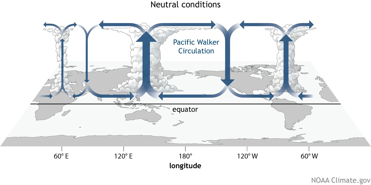
The atmosphere is driven in large part by the sun. It is generally more dynamic. The ocean covers 70% of the earth’s surface but has tremendous thermal and physical inertia. It is generally less dynamic. Interaction between the two is the primary mechanism for getting incoming solar energy from places where it is delivered in excess (the equator) to places where it is lacking (the poles/everywhere else). The various patterns through which they interact have different names. One pattern commonly affecting conditions in the Colorado River Basin is called the Walker Circulation.

Walker Circulation patterns related to La Niña and El Niño
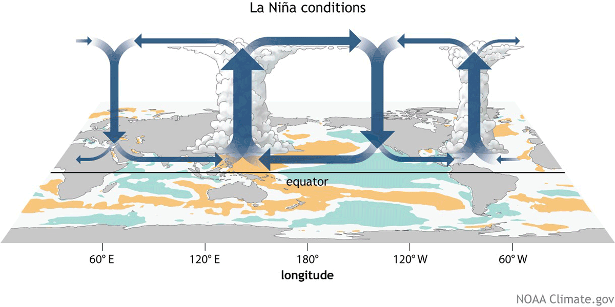
The Walker Circulation is an atmospheric “loop.” The lower part of the loop is defined by the westward flow of the tradewinds across the Equatorial Pacific Ocean. The top part of the loop is defined by the eastward return of that air at higher altitude. Air is heated near the surface of the tropical Pacific as it travels west: saturating, rising and condensing, eventually sinking back down toward the surface on the eastern side of the loop as cooler, drier air. The strength of this loop is defined by the intensity and duration of these winds.
The ocean, of course, eventually responds. As the Walker Circulation intensifies, the tradewinds pile warmer surface waters up in the Western Pacific. Colder, deeper waters in the eastern Pacific rise to the surface to take their place, and sea surface temperatures there trend cooler than normal
This is the typical pattern observed in La Niña.
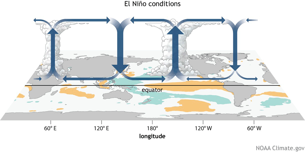
With El Niño, the opposite occurs: the tradewinds weaken, leaving warmer water near the surface off the northwest coast of South America, and the mass of warm, saturated, rising air that would otherwise be located over Indonesia shifts east with it.
What does this mean for the Colorado River Basin?
Because the ramped-up pattern tends to shift the Pacific storm track north across the Pacific Northwest and on into the Northern Plains, La Niña winters typically spell dry conditions for the Colorado River Basin. Generally speaking, if the headwaters of the Colorado River receive snowfall in a La Niña year, it is typically in the source area of the Green River watershed.
El Niño winters, by contrast, often mean significant winter precipitation for the Lower Basin, with the mountainous areas of Arizona, southern Utah and southwest Colorado (the San Juans in particular) often receiving above-average snowfall. In Arizona, La Nina does often make for a decent monsoon, though this is also dependent on several other factors.
Can the weather pattern change during the water year?
When the Walker Circulation is strong, the loop is self-sustaining and there is essentially nothing that can stop it. Cooler water at the surface of the Eastern Pacific does not feed storm activity, and the cold, dry air descending on the region does nothing to change this feedback effect. The makings of an El Niño event, by contrast, contain all the elements needed for its dispersal.
Warmer, saturated air rising over the Eastern Pacific means enhanced atmospheric convection and large, often poorly organized low pressure systems. The enhanced evaporation from a warmer ocean condenses as it rises, eventually cooling the surface waters but heating the atmosphere above it. These low pressure systems also create a subtle difference in mean sea level: sea level is slightly higher underneath them, and this gradient naturally disperses the warm surface waters of El Niño away from this center.
This is why La Niña events often repeat in consecutive years, while El Niño often stands alone. Thus, the projected three-peat La Niña for this winter – and hence the prospect of continued dry conditions, which could mean more unfortunate news for the Colorado River Basin.
Podría ser un triciclo de La Niña. ¿Qué es exactamente La Niña?
Por Orestes Morfin, Analista Sénior de Políticas
Esta es la parte del año en la que nosotros, como profesionales de agua, seguimos ansiosamente el clima para determinar si las predicciones sobre el “tipo” de año que predecimos realmente se cumplen. Esperamos que este año hidrológico 2023 se vea influenciado por un patrón climático que se llama La Niña, así que permítanme explicar lo que eso significa y por qué es tan importante para los administradores del agua.
¿Cómo se desarrollan los patrones climáticos?
La atmósfera es impulsada en gran parte por el sol. Generalmente es más dinámico. El océano cubre el 70% de la superficie terrestre pero tiene una tremenda inercia térmica y física. Generalmente es menos dinámico. La interacción entre los dos es el mecanismo principal para llevar energía solar desde lugares donde se entrega en exceso (el ecuador) hasta lugares donde falta (los polos/en cualquier otro lugar). Los diversos patrones a través de los cuales interactúan tienen diferentes nombres. Un patrón que comúnmente afecta las condiciones en la cuenca del Río Colorado se llama la Circulación Walker.
La Circulación Walker y La Niña/El Niño
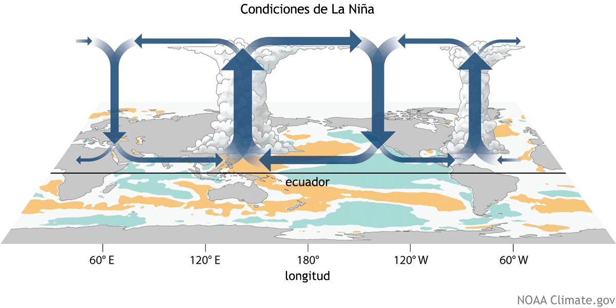
La Circulación Walker es un circuito atmosférico. La parte inferior del circuito está definida por el flujo hacia el oeste de los vientos alisios a través del Océano Pacífico Ecuatorial. La parte superior del circuito está definida por el retorno hacia el este de ese aire a mayor altitud. El aire se calienta cerca de la superficie del Pacífico Tropical a medida que viaja hacia el oeste: se satura, sube y se condensa, y finalmente se hunde hacia la superficie en el lado este del circuito como aire más frío y seco. La fuerza de este circuito se define por la intensidad y duración de estos vientos.

El océano, por supuesto, eventualmente responde. A medida que se intensifica la Circulación Walker, los vientos alisios acumulan aguas superficiales más cálidas en el Pacífico Occidental. Aguas más frías y profundas en el Pacífico Oriental suben a la superficie para ocupar su lugar, y las temperaturas de la superficie del mar tienden a ser más frías de lo normal.
Este es el patrón típico observado en La Niña.
Con El Niño, ocurre lo contrario: los vientos alisios se debilitan, dejando agua más cálida cerca de la superficie frente a la costa noroeste de América del Sur, y la masa de aire cálido, saturado y ascendente que de otro modo se ubicaría sobre Indonesia se desplaza hacia el este con ella.

¿Qué significa esto para la cuenca del Río Colorado?
Debido a que el patrón intensificado tiende a cambiar la trayectoria de las tormentas del Pacífico hacia el norte, los inviernos de La Niña significan condiciones secas para la cuenca del Río Colorado. En términos generales, si los areas fuentes del Río Colorado reciben nevadas en un año de La Niña, es típicamente en el área de origen de la cuenca del Río Green.
Los inviernos de El Niño, por el contrario, típicamente significan una precipitación invernal significativa para la Cuenca Inferior, y las áreas montañosas de Arizona, el sur de Utah y el suroeste de Colorado (en particular, San Juan) reciben nevadas superiores. En Arizona, La Niña puede significar un buen monzón, aunque esto también depende de varios otros factores.
¿Puede cambiar el patrón del tiempo durante el año hidrológico?
Cuando la Circulación Walker es fuerte, el ciclo es autosuficiente y esencialmente no hay nada que pueda detenerlo. El agua más fría en la superficie del Pacífico Oriental no contribuye a la actividad de tormentas, y el aire frío y seco que desciende sobre la región no hace nada para cambiar este efecto de retroalimentación. Los ingredientes de un evento de El Niño, por el contrario, contienen todos los elementos necesarios para su dispersión.
El aire más cálido y saturado que se eleva sobre el Pacífico Oriental significa una mayor convección atmosférica y grandes sistemas de baja presión mal organizados. La evaporación mejorada de un océano más cálido se condensa a medida que asciende, enfriando eventualmente las aguas superficiales, pero calentando la atmósfera sobre ellas. Estos sistemas de baja presión también crean una diferencia sutil en el nivel promedio del mar: el nivel del mar es ligeramente más alto debajo de ellos, y este gradiente dispersa naturalmente las cálidas aguas superficiales de El Niño lejos de este centro.
Por eso los eventos de La Niña pueden repetir en años consecutivos, mientras que El Niño dura típicamente no mas un año. Por lo tanto, esperamos una tercera La Niña consecutiva para este invierno, y por lo tanto, la probabilidad de condiciones secas continuas, lo que podría significar más noticias malas para la cuenca del Río Colorado.