The major reservoirs in the Colorado River Basin continue to be at historically low levels, even after one good snowpack year. The Bureau of Reclamation has taken several actions to mitigate the impact of drought and aridification on the Colorado River system reservoirs. This includes the initiation of a National Environmental Policy Act (NEPA) process to modify the current operating guidelines for Glen Canyon Dam, which holds back Lake Powell, as well as for Hoover Dam which holds back Lake Mead.
Lake Mead is the largest reservoir in the Colorado River system, impounded by Hoover Dam and located on the Arizona-Nevada border. Lake Mead is operated in coordination with Lake Powell, which is directly upstream, created by Glen Canyon Dam, and the second largest reservoir in the Colorado River Basin. Unlike Lake Powell, the inflows into Lake Mead are largely known and regulated.

Lake Mead elevations are primarily determined by the water released from Lake Powell. Between 2007 and 2018, about 92% of total inflows into Lake Mead came from Lake Powell and 8% came from intervening flows between the Glen Canyon and Hoover dams. During that same period, the average releases from Lake Powell were approximately 8.9 million acre-feet (MAF) per year. However, as Lake Powell dips to lower elevations, releases may be reduced to protect Glen Canyon Dam infrastructure, as is being evaluated in the current SEIS process.
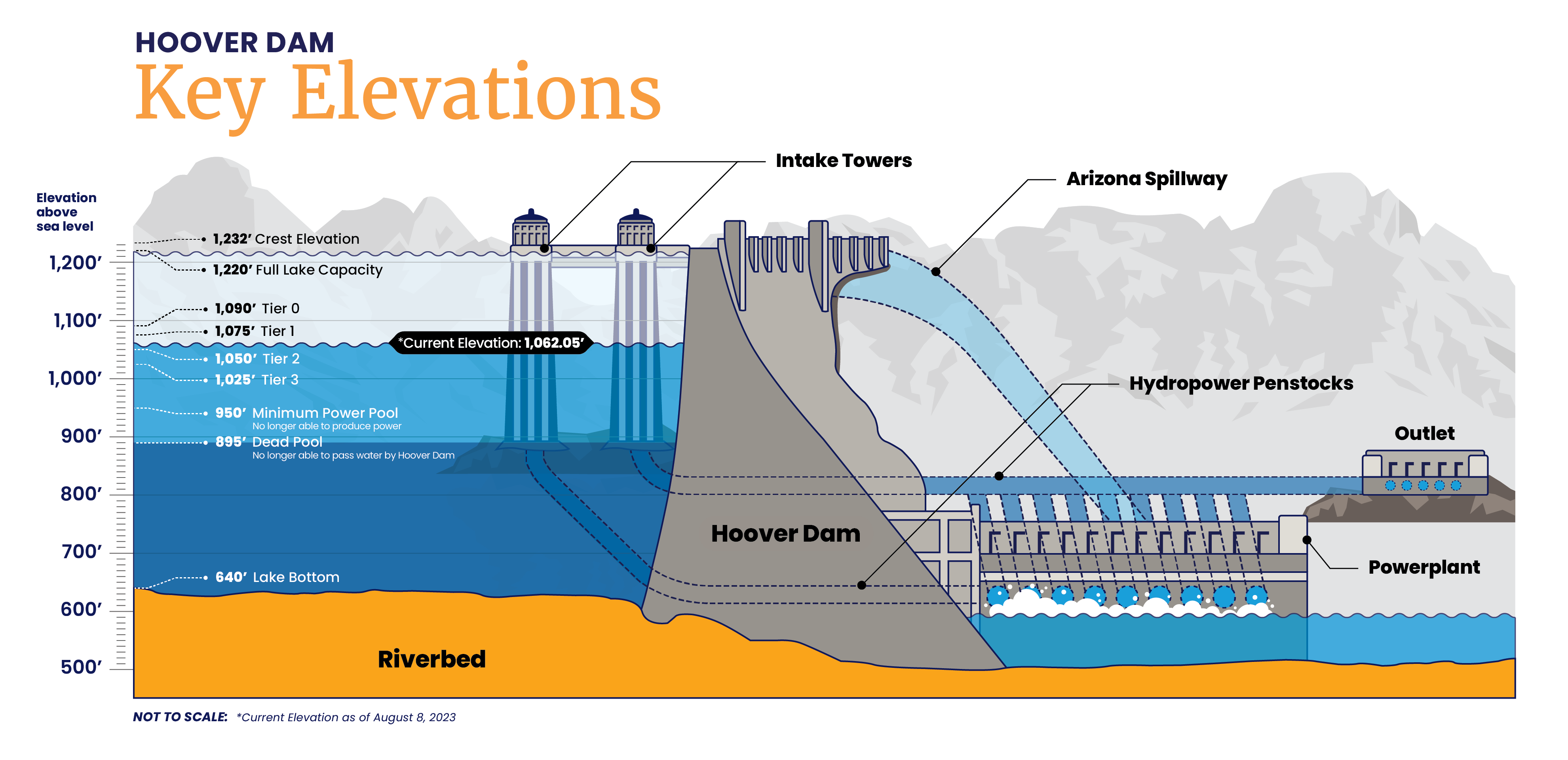
The water levels at Lake Mead are also critically important, as they determine operational decisions per the 2007 Interim Guidelines, the Lower Basin Drought Contingency Plan (DCP) and Minute 323. Thus, it’s important to understand the noteworthy elevations at Hoover Dam and what they mean.
First, Lake Mead’s normal “operating pool” is at elevation 1,219.6 feet, at which point there is 26.12 MAF in the lake.
Lake Mead continues to operate in normal conditions until the lake reaches 1,090 feet. This is the first level – Tier Zero – where DCP contributions are triggered. At Tier Zero, Arizona and Nevada make DCP contributions, along with Mexico under Minute 323.
Tier 1, which is the first shortage elevation in the 2007 Interim Guidelines, is triggered at an elevation of 1,075 feet.
Various other tiers were designated in the 2007 Interim Guidelines and DCP, with the deepest shortage being Tier 3 at 1,025 feet. When Lake Mead is at or below 1,025 feet, the total shortage volume between the Lower Basin States and Mexico is 1,375,000 acre-feet, with 720,000 acre-feet assigned to Arizona. Declining to elevation 1,025 also triggers a process for additional responsive actions to protect the system.
If Lake Mead were to hit 950 feet – power pool elevation – Hoover Dam would no longer be able to produce power. And if Lake Mead fell to 895 feet – dead pool – Hoover Dam would no longer be able to pass water downstream. Operating below power pool and near dead pool would result in increased risk to water delivery and would have adverse impacts on downstream resources and hydropower.
Lake Mead elevations are also dependent on the consumptive use needs in the lower Colorado River basin. Altogether, there is a supply/demand imbalance. To help alleviate this imbalance, many entities in the Lower Basin over the last decade have created system conservation or intentionally created surplus (ICS), which leaves water in Lake Mead.
More recently, the Department of Interior announced potential actions to reduce water consumption across the basin in light of critically low water supplies and dire hydrological projections. Some of these potential actions included assessing evaporation, seepage and losses, and determining appropriate beneficial use standards in the Lower Basin. These are actions that are being considered in parallel to modifying operations at the Glen Canyon Dam and Hoover Dam as contemplated in the SEIS.
KRA: Water Supply
Providing a reliable CAP water supply for the short- and long-term


